On summer afternoons, tourists move steadily along Constitution Avenue and Independence Avenue, crossing the National Mall between museums, memorials, and government buildings. School groups crowd sidewalks near the Capitol. Commuters wait through traffic lights. Food trucks idle beneath the shadows of marble monuments.
Almost no one realizes that beneath many of these streets once flowed water.
Long before Washington became a city of traffic circles, motorcades, and Metro tunnels, the nation’s capital was envisioned as a canal city — a grand American counterpart to the waterways of Amsterdam, Venice, and Paris. Boats once moved through the heart of the city where cars now crawl through rush hour congestion. Barges carrying lumber, tobacco, flour, whiskey, coal, and stone drifted past muddy embankments near what would later become the National Mall.
The canals of Washington, DC have largely disappeared from public memory, buried beneath pavement and federal expansion. But for much of the 19th century, they represented one of the capital’s boldest and most ambitious engineering dreams.
America’s road system was primitive and unreliable. Dirt roads became rivers of mud during storms, and transporting goods over land was painfully slow. Political leaders and business interests believed canals offered the best solution for connecting eastern cities to inland markets and western territories.
President Washington strongly supported canal development. When plans for the new federal city were being drafted by Pierre L’Enfant in the 1790s, Washington envisioned more than wide boulevards and monumental buildings. He imagined a functioning commercial city built around waterways that could connect the interior of the country to the expanding capital.
Inspired partly by the grand canals of Europe, early planners proposed a canal system that would link the Eastern Branch — now known as the Anacostia River — with the Potomac River and the western trade routes beyond.
The canal would eventually connect with Tiber Creek, a natural waterway that once flowed openly through parts of the capital before being buried underground during later development.
At the time, the idea felt visionary.
Building canals, however, required money the young nation did not easily possess.
In 1796, city leaders attempted to raise construction funds through public lotteries — a surprisingly common method of financing infrastructure projects in early America. The effort failed to generate enough support, and progress stalled for years.
Congress stepped in during 1802 by granting a charter to the Washington Canal Company, but financing problems continued to plague the project. Little visible construction occurred.
Finally, in 1809, lawmakers reorganized the effort under a new canal company and authorized $100,000 in capitalization, a substantial investment for the era.
The following year, Washington staged a ceremonial beginning.
On May 2, 1810, dignitaries gathered in southeast Washington for a groundbreaking ceremony attended by and other government officials. The canal represented more than transportation. It symbolized national growth, commercial ambition, and confidence in the future of the capital city.
Then history intervened.
Construction slowed dramatically during the, when national attention and resources shifted toward military survival.
British troops invaded Washington in 1814, burning government buildings and leaving much of the city in crisis. Canal construction paused while the capital struggled to recover from war.
Work resumed in 1815, but progress remained slow and expensive. Engineers wrestled with unstable ground, tidal flooding, labor shortages, and the enormous logistical challenge of cutting a manmade waterway through the growing city.
The canal system ultimately required more than four decades to fully complete.
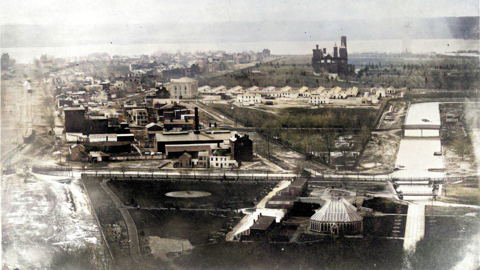
By the mid-19th century, a navigable channel crossed through the center of Washington, connecting the Anacostia River to Tiber Creek and eventually linking with the Chesapeake and Ohio (C&O) canal in Georgetown.
For a brief moment, the dream worked.
The Washington Canal became a working commercial artery.
Flat-bottomed boats and barges carried cargo directly through the city. Wharf districts developed near the canal’s edges. Warehouses, markets, and industrial businesses clustered around the waterway. Laborers loaded freight while mule teams hauled boats along towpaths beside the canal.
Visitors arriving in Washington during the early and mid-1800s encountered a very different capital than the ceremonial city known today.
Instead of open lawns and museums stretching across the National Mall, portions of the area contained muddy docks, warehouses, industrial yards, and slow-moving canal traffic. Water, commerce, and politics existed side by side.
But maintaining canals in Washington proved difficult from the beginning.
The same geography that made Washington vulnerable to flooding also complicated canal operations.
Sediment constantly accumulated in the shallow channels. Tidal changes affected water levels. During hot summers, stagnant water mixed with sewage runoff and industrial waste, creating foul odors that residents frequently complained about.
Tiber Creek itself became heavily polluted.
As the city expanded, public frustration with the canal system grew. Some viewed the waterways as unhealthy and outdated. At the same time, a new transportation revolution was emerging across America.
Railroads.
Unlike canals, rail lines operated year-round, moved goods more quickly, and did not depend on water conditions. By the late 19th century, railroads increasingly dominated long-distance transportation and commercial shipping.
Washington’s canals slowly lost their economic relevance.
As canal traffic declined, city planners began transforming the landscape.
Sections of the canal were covered over or filled in entirely. Tiber Creek disappeared underground beneath sewer systems and street grids. Former canal corridors evolved into roads and public spaces as Washington modernized during the late 1800s and early 1900s.
Eventually, the broad ceremonial avenues surrounding the National Mall emerged atop portions of the old canal routes.
What had once been muddy waterways crowded with barges became Constitution Avenue and Independence Avenue — now among the busiest and most recognizable streets in the nation’s capital.
The transformation was so complete that most residents eventually forgot the canals had ever existed.
Traces of Washington’s hidden waterways still remain beneath the modern city.
Engineers and construction crews occasionally uncover remnants of old canal walls during infrastructure projects. Historians continue mapping the buried route of Tiber Creek beneath federal buildings and downtown streets. In Georgetown, sections survive as part of the C&O Canal National Park, where towpaths that once served mule teams now serve joggers, cyclists, and tourists.
The canals may be gone from the surface, but they continue shaping the geography of Washington in subtle ways.
More importantly, they reveal a forgotten version of the capital — one built not only for government and monuments, but for commerce, industry, and transportation.
Related Links and Sources